Aligning rasters for analysis
I’ve been working on tooling the past few days, mostly gathering in one place scripts I’ve written for other projects.
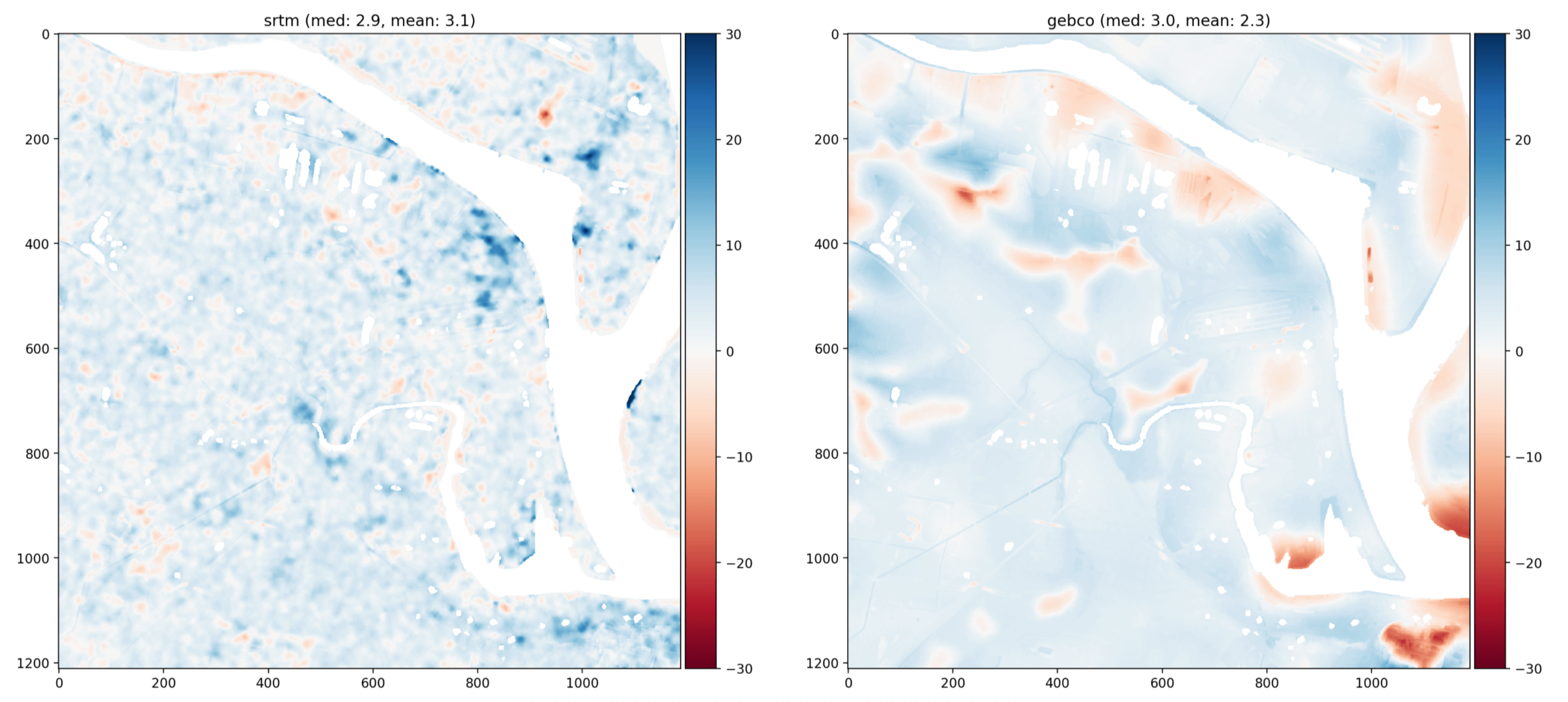
A key part of my workflow is loading multiple rasters into spatially-aligned arrays of the same shape for analysis. This lets me compare the interpolated values over the same area of interest to get a sense of the dataset quality
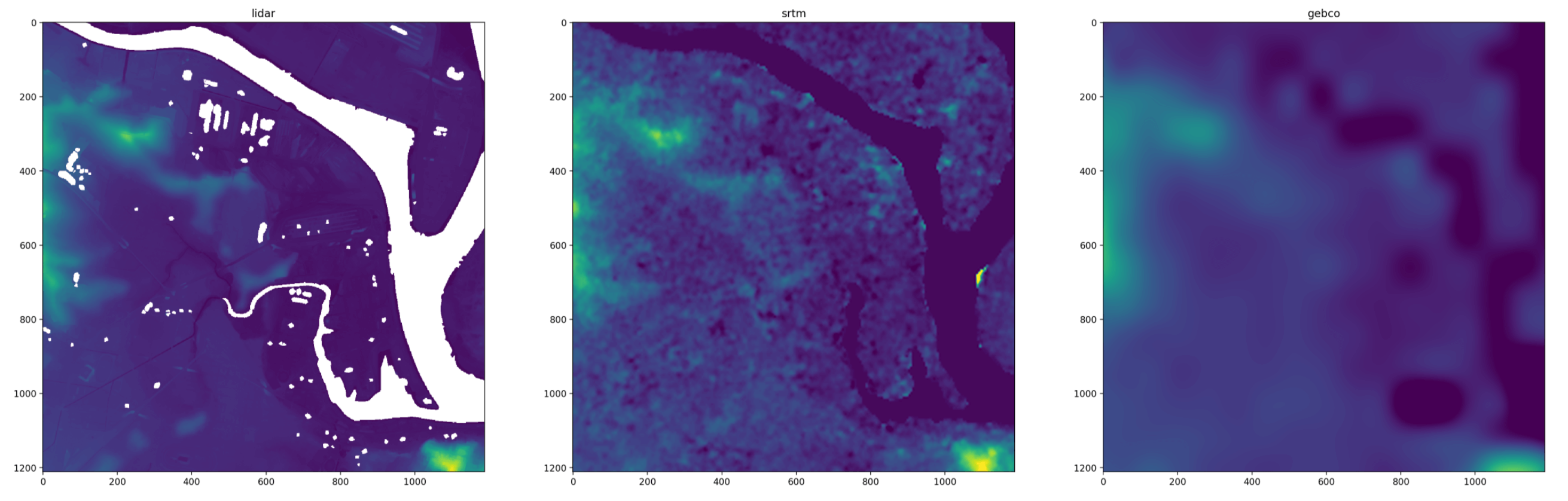
and because the arrays are the same shape it’s easy to do vectorised analysis, like the difference against a hi-res lidar DEM
Here’s the code I use:
import math
import os
import random
import string
import subprocess
import sys
import tempfile

import geopy.distance
import matplotlib
import numpy as np
import pyproj
import rasterio


WGS84_LATLON_EPSG = 4326
TMP_FOLDER = '/tmp/raster-utils/'

def run_cmd(cmd):
    '''Run a command.

    Raises ValueError if nonzero exit code.
    '''
    r = subprocess.run(cmd, shell=shell, capture_output=True)
    assert r.returncode == 0


def random_string(n=16):
    return ''.join(random.choices(string.ascii_lowercase, k=n))


def tmp_file_path(extension='', filename=None):
    '''Random temporary file.'''
    os.makedirs(TMP_FOLDER, exist_ok=True)
    filename = filename or random_string(16) + extension
    path = os.path.join(tmp_folder, filename)
    return path


def offset_lat_lon(lat, lon, dist, bearing_degrees):
    '''
    Shift a latlon point by a Cartesian vector.
    From github.com/kellydunn/golang-geo/blob/master/point.go
    '''
    dist_ratio = dist / radius_of_earth(lat)
    bearing = math.radians(bearing_degrees)
    lat_1 = math.radians(lat)
    lon_1 = math.radians(lon)

    lat_2_part_1 = math.sin(lat_1) * math.cos(dist_ratio)
    lat_2_part_2 = math.cos(lat_1) * math.sin(dist_ratio) * math.cos(bearing)
    lat_2 = math.asin(lat_2_part_1 + lat_2_part_2)

    lon_2_part_1 = math.sin(bearing) * math.sin(dist_ratio) * math.cos(lat_1)
    lon_2_part_2 = math.cos(dist_ratio) - (math.sin(lat_1) * math.sin(lat_2))
    lon_2 = lon_1 + math.atan2(lon_2_part_1, lon_2_part_2)

    lat_2 = math.degrees(lat_2)
    lon_2 = math.degrees(lon_2)
    return lat_2, lon_2


def radius_of_earth(lat):
    '''
    Find the radius of the Earth at a given latitude. Vectorised.
    Formula and data from https://en.wikipedia.org/wiki/Earth_radius
    '''
    r_1 = 6378137.0  # Earth equatorial radius
    r_2 = 6356752.3  # Earth polar radius

    lat = np.radians(lat)
    part_1 = r_1**4 * np.cos(lat)**2 + r_2**4 * np.sin(lat)**2
    part_2 = r_1**2 * np.cos(lat)**2 + r_2**2 * np.sin(lat)**2

    return np.sqrt(part_1 / part_2)


def load_aligned_raster(path, epsg=None, bounds=None, shape=None, bounds_epsg=None, align_to=None):
    '''Load raster from file.

    epsg(int): reproject raster.
    bounds: in final cps (epsg if provided else file)
    shape: control resolution (for aligning grids, will interpolate)
    bounds_epsg: if bounds aren't in new epsg.
    align_to: rasterio file handle, to take parameters from.

    Returns both numpy array and rasterio file handle.
    '''

    # Auto aligned to another file.
    if align_to is not None:
        return load_aligned_raster(
        path,
        epsg=align_to.crs.to_epsg(),
        bounds=align_to.bounds,
        shape=align_to.shape,
    )

    # Normalise inputs.
    if isinstance(epsg, str):
        epsg = epsg.lower().replace('epsg:', '')
        epsg = int(epsg)
    if bounds is not None:
        bounds = np.asarray(bounds)
    if isinstance(shape, int):
        shape = shape, shape

    # Get raster metadata.
    with rasterio.open(path) as f:
        f_res = f.res
        f_epsg = f.crs.to_epsg()
        f_bounds = np.array(f.bounds)
        f_shape = f.shape

    # Check if any transforms are needed.
    transform_needed = False
    if epsg and epsg != f_epsg:
        transform_needed = True
    if (bounds is not None) and not np.allclose(bounds, f_bounds):
        transform_needed = True
    if shape and shape != f_shape:
        transform_needed = True

    # Do transform.
    if transform_needed:
        transformed_path = tmp_file_path('.tiff')
        cmd = [
            'gdalwarp',
            '-novshiftgrid',
            '-r', 'bilinear',
            '-multi',
            '-ot', 'Float32',
            '-q',
            '-wo', 'NUM_THREADS=val/ALL_CPUS',
            '-co', 'NUM_THREADS=ALL_CPUS',
            '-co', 'ZLEVEL=1',
            '-co', 'COMPRESS=DEFLATE',
            '-co', 'PREDICTOR=1',
            '-co', 'BIGTIFF=YES',
            '-co', 'TILED=YES',
        ]
        if epsg:
            cmd += ['-t_srs', f'EPSG:{epsg}']
        if shape:
            cmd += ['-ts', str(shape[1]), str(shape[0])]
        if bounds is not None:
            cmd += ['-te'] + [str(x) for x in bounds]
        if bounds is not None and bounds_epsg:
            cmd += ['-te_srs', f'EPSG:{bounds_epsg}']

        cmd += [path, transformed_path]
        run_cmd(cmd)
    else:
        transformed_path = path

    # Load.
    with rasterio.open(transformed_path) as f:
        a = f.read(1, masked=True, out_dtype=float)
        a = np.ma.filled(a, np.nan)

    # Validate.
    if shape:
        assert shape == f.shape


    return a, f


def radius_bounds(centre_lat, centre_lon, size_m):
    radius_m = np.sqrt(size_m**2 * 2)
    top, right = offset_lat_lon(centre_lat, centre_lon, dist=radius_m, bearing_degrees=45)
    bottom, left = offset_lat_lon(centre_lat, centre_lon, dist=radius_m, bearing_degrees=180+45)
    bounds = rasterio.coords.BoundingBox(left, bottom, right, top)
    return bounds
Datasets can then be loaded like this:
# Make bounds.
centre_lat = -32.903
centre_lon = 151.752
size_m = 30*100
bounds = radius_bounds(centre_lat, centre_lon, size_m)

# Paths.
lidar_path = '~/gpxz-dataset/data/audem.vrt'
srtm_path = '~/gpxz-dataset/data/srtm30m.vrt'
gebco_path = '~/gpxz-dataset/data/gebc2020.vrt'

# Load rasters.
a_lidar, f_lidar = load_aligned_raster(lidar_path, bounds=bounds, bounds_epsg=WGS84_LATLON_EPSG)
a_srtm, f_srtm = load_aligned_raster(srtm_path, align_to=f_lidar)
a_gebco, f_gebco = load_aligned_raster(gebco_path, align_to=f_lidar)